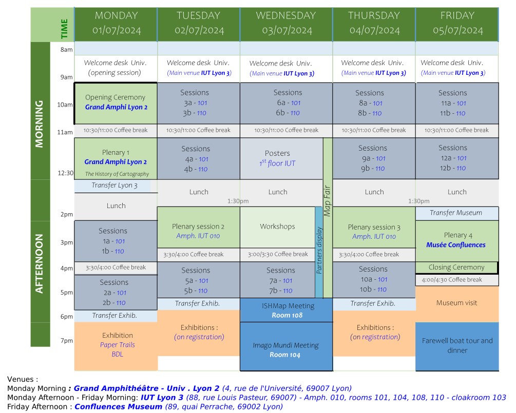
Programme
Reminder: The official language of the conference will be English. There will be no simultaneous translation.
- Monday 01/07/2024
-
- Morning
-
Venue: Université Lumière Lyon 2, Grand Amphithéâtre
(4, rue de l’Université, 69007 Lyon)
8:30 am – 9 am: Welcome desk
9 am – 9:30 am: Opening Ceremony
9:30 am – 10:30 am: Imago Mundi Homage - Chair: E. Vagnon
11 am – 12:30 am: Plenary Session1: Steps aside - Chair: W. Bracke- Cattaneo A M, Mapping the early modern connected world from Japan: Analysis of a 17th Century Japanese Map from the Kōchi Prefectural Library
- Kantor I, The transatlantic slave trade in manuscript and printed cartographic sources: some evidences and configurations between 1648 and 1815
- Edney M H, The myths of transformation and translatio in the history of cartography
12:30 am – 1:30 pm: Transfer Lyon 3 - Lunch - Afternoon
-
Venue: IUT Université Jean Moulin Lyon 3
(88, rue Louis Pasteur, 69007 Lyon)
1:30pm – 2:00pm: Welcome desk
2 pm – 3:30 pm: Oral presentations 1a - Why make globes? - Chair: J. Močičková- De Biaggi E, Sirdey J, Gauthiez B, The hectic history of a globe made in Lyon in 1700
- King R J, The southern continent on the globe published in Lyon by Guillaume Nicolai Belga in 1603
- Phelippot G, On the "Observations de Mrs de l’Académie Royale des sciences": A new image of the world in Nicolas de Fer’s Mappemonde
- Pegg R A, Late Ming Chinese scholars and European Jesuits make a terrestrial globe
2 pm – 3:30 pm: Oral presentations 1b - Materiality of maps - Chair: N. Millea
- Depuydt J, Wonderful woodblocks and curious copperplates: The hidden gems behind maps
- Storms M, Modified maps – Traces of use and ownership on early modern maps
- Trachet J, Illuminating triangulation methods in 16th Century Bruges: The application of MLRI to reveal to reveal incised underdrawings
- Khotimsky D A, Robles Macías L A, From travelogue to map: Alessandro Zorzi’s forgotten sketches of Eastern Europe and the Middle East
4 pm – 5:30 pm: Oral presentations 2a – Maps and travels - Chair C. Dando- Piccolotto Siqueira Bueno B, Landscape archaeology exercises: The first general map of Brazil between travellers' accounts and watercolours
- Chant E, Scenery and sea: Mapping early maritime cruise tourism in Patagonia
- Altić M, Geography at the intersection of East and West: French Jesuit traveler maps of 17th century Vietnam
- Gaspar J A, Magnetism, navigation, and cartography in the early modern period: An elusive and problematic relationship
4 pm – 5:30 pm: Oral presentations 2b – Discourse-oriented maps - Chair I. Demhardt
- Roelofs B, The emergence of map-thinking in Dutch medicine. Investigating cholera maps from the Netherlands (1832-1866)
- Gabriel J, City planning or racist prevision? How urban renewal maps usurped democratic process in the urban North
- Butler K, A judicial pub crawl: The influence of changing liquor licensing laws on the distribution and circulation of drinks maps in late 19th century Britain
- Van Schaik A-R, Analyzing early modern story maps: An interdisciplinary approach
6:30 pm – 8:30 pm: Paper trails – Maps and images of travel in France and elsewhere, 19th – 21st Century
Diderot Library – Descartes (Bibliothèque Diderot de Lyon – site Descartes)
5, parvis René Descartes, 69007 Lyon
- Tuesday 02/07/2024
-
- Morning
-
Venue: IUT Université Jean Moulin Lyon 3
(88, rue Louis Pasteur, 69007 Lyon)
8 am – 9 am: Welcome desk
9 am – 10:30 am: Oral presentations 3a – Imaging the world - Chair: C. Hofmann- Zheng M, Intersecting worlds: The re-interpretation, transformation, and integration of Jesuit mapping and geographical knowledge in Zhang Huang’s Tushu Bian
- Martinez C, Terra Australis in a 17th century Spanish manuscript atlas, or how to read a map in a sequence
- Mann E, Centering the Caribbean: A tale of two 17th century Atlases
- Močičková J, Vokurka M, Circulation of maps and geographical data in the mid-18th century central Europe
9 am – 10:30 am: Oral presentations 3b – Identity and boundaries - Chair: P. Svatek- Warminski A, Heritage, identity, and mapping: Digitally investigating the archaeological and cultural landscapes in imperial cartography of the Levant and Iraq
- Novaes A. R., Mapping travels and encounters in the Amazon forest: Towards a transnational history of boundary-making at the River Verde
- Mukherjee S, Follow the river: Discovering "traditional" borders in late Qing frontier management
11 am – 12:30 am: Oral presentations 4a – Mapping Eastern Europe - Chair: J. Gabriel- Ion C, Cantemir’s Moldavia in European cartography. Putting eastern Europe on the map in the age of Enlightenment
- Török Z G, A "Petite révolution": Sebastian Münster, Johannes Honter and their maps of Transylvania
- Filipova H, Plus ultra: Ideology of Russian expansion in the Hetmanate and mapping land surveys in the 1710-1720’s
- Hoogvliet M, de Vries A, Deconstructing, decolonizing and decentering the Blaeu Atlases and maps
11 am – 12:30 am: Oral presentations 4b - Know your enemy - Chair: R. Leca- Soh J, Emergence of islands in 18th and 19th century Korean cartography: Mapping, geopolitics and proto-nationalism
- Hao L, Exploring the Chinese cartographic material in 17th century Korea: Focus on the origin of Kim Su-Hong's Cheonha Gogeum Daechong Pyeollamdo
- Yang Y, Knowledge production and reading of maps: The mapmaking and changes of Kim Suhong’s Choenha gogeum daechong pyoellamdo
- Son K, Navigating changes: Ming’s coastal defense perception shift during the Imjin War (1592) and its cartographic representation
- Afternoon
-
1:30 pm – 3:30 pm: Plenary session 2 – The building of discourse in maps - Chair: A. Hiatt
- Hellström P, Jean-Baptiste d’Anville’s unmapping of Africa
- Benison L, Place names or place claims? The discursive power of toponyms on Dutch map of Hollandia Nova
- Bockelman B, Missionary frontier to map metropole: A tale of two Thomases and their English map of Patagonia, 1771-1774
- Besse J-M, Censorship and cartography. The Roman Inquisition and the diffusion of printed maps in the late 16th century
4 pm – 5:30 pm: Oral presentations 5a – Environment as resources - Chair: E. d'Orgeix- Pérez Machado R P, Historical cartography in the socio-environmental atlas of Lençòis Maranhenses – Northeast (Brazil)
- Edelson S M, Work and trade the edges of empires: The political economy of urban views in Ogilby’s America (1671)
- Robles Macías L A, Unveiling the journey of Juan Vespucci’s printed polar hemispheres (ca. 1522-1524)
- Furtado J F, "The map of North America" by Hermann Moll, and cartographic instrumentalisation method used at the Congress of Utrecht (1712-1715)
4 pm – 5:30 pm: Oral presentations 5b – On map semiology - Chair: Q. Morcrette- Choi T Y, Vignettes and visual nostalgia in 19th century British maps
- Svenningsen S R, Colorful arrows and xerox copies. Towards a history of cartography in Cold War military operational plans
- Zanin C, Trémélo-Apers M-L, Graphic semiology: Old fashion or not?
- Dando C, American redlining maps as iconic images
6:00 pm – 8:00 pm: Exhibitions visits
Representing the Far Away, an European View
Lyon Municipal Library (Bibliothèque Municipale de Lyon), Lyon-Part Dieu
Teaching Maps: On the trail of cartography at the University of Lyon
University Jean Moulin Lyon 3, Manufacture des Tabacs University Library (Bibliothèque Universitaire)
Vulnerabilities – What do maps say?
Lyon Municipal Archives (Archives Municipales de Lyon)
The detail and the whole. Maps and images of the Rhône and Lyon area
Rhône Department Archives (Archives départementales du Rhône et de la Métropole de Lyon)
- Wednesday 03/07/2024
-
- Morning
-
Venue: IUT Université Jean Moulin Lyon 3
(88, rue Louis Pasteur, 69007 Lyon)
8 am – 9 am: Welcome desk
9 am – 10:30 am: Oral presentations 6a – Explorations, ideas and realities - Chair: A. Chassagnette- Griffioen M, Tracing travelers’ map encounters in Early Modern travel journals (1500-1800)
- Isaksen L, An un-noticed cartographic revolution? Islamic world maps and the cosmic imaginary
- Vannieuwenhuyze B., A summer full of map encounters. Cartographic literacy and the ordinariness of maps in the Netherlands in 1823
- Dorofeeva-Lichtmann V, Conceptualising terrestrial space in early China reconsidered through traditional cartography: Insularity versus mainland
9 am – 10:30 am: Oral presentations 6b - Ancient sources in cartography - Chair: G. Tolias- Macchioro R, At the crossroad between historiography and geography: Exploring maps in Galvaneus de la Flamma’s manuscripts
- Blümer B, Layers of the “Liber Insularum Archipelagi”: Rereadings its Latin past
- Richard Dalsace J, Three sons of Noah for three parts of the world: The making of a cartographic convention through Carolingian networks of knowledge
- Favero F, Galvaneus de la Flamma’s "Cronica universalis": new findings about John of Carignano
11 am – 12:30 am: Posters- Agrech A, Madagascar: From base maps to data patchwork
- Bridier S, Le Douarin L, Bouffier S, Suarez R, Cartomundi 2.0, a new online catalogue for old maps in 2023. Progress and challenges
- Chodejovska E, Rural landscape in Central Europe as mapped in the pre-modern Period. Local maps in the Czech Republic
- Cruz M N, Mapping ideas of race in the age of the Enlightenment: A historical analysis of the mural maps of Longchamps and Janvier (1754)
- De Potestad P, From tracks to traces: Mapping of routes on the north face of Mont Blanc
- Germain M, Candela T, From traditional cartography to webmapping: New perspectives for natural risk management
- Hofmann C, Netchine E, Garel-Grislin J, East Asian cartography at the Bibliothèque Nationale de France: Construction and composition of a national collection (17th - 20th Centuries)
- Jardim M E, Art, technology and chemistry in the photo-reproduction of maps and drawings by blueprinting and related reprographic processes
- Leeflang J, A new carto-bibliography of Dutch-made maps in bibles (c. early 16th - mid 18th Centuries)
- Lelo K, Travel itineraries in Rome: An investigation of early modern sources across Europe
- Mazagol P-O, Maps under the Loire river – The Gorges de la Loire as a strategic mapped area
- Rodriguez Wittmann K, The Life and works of an Italian in the Fortunate islands: Leonardo Torriani (c. 1560-1628) and the first urban plans of the Canaries
- Tronchère-Cottet H, Ducourthial C, Levelling data from 19th Century military plans of Lyon and GIS: A method for analyzing the evolution of topography at the service of archeology
- Tůmová M, Practical or/and beautiful? Decoration of manuscript maps in Bohemia in the 18th and 1st half of the 19th Century
11 am - 5 pm: Map Fair - Afternoon
-
1:30 pm – 3:30 pm: Workshops
- Cordier C, Mandelblatt B, Bermúdez J, Duranton A, Liang Y-G, Mapping empires in the early modern era, between description of space and territorialization of power
- Dym J, Parker K, Imago Mundi: Agenda for A Second Century Promoting Map History
- Gauthiez B, De Biaggi E, First approaches to a Chinese map of Lyon
- Myrda G, GIS-centric historical data modeling based on the materials of Karol Perthées
3:30 pm – 5 pm: Oral presentations 7a - Mapping of urban - Chair: J.-M. Besse
- D’Orgeix E, Mapping waters: Bélidor’s L’architecture hydraulique (1737-1750) and the birth of urban hydraulic monograph’s in the 18th Century
- Dumasy-Rabineau, A Map of Venice and its lagoon in late 15th Century
- Shaalan C, Water and toponymy in Alexandria, Egypt (1850-1950)
- Grosjean E, “God created the world, the Dutch made Holland”: More than six centuries of water management through urban cartography of the city of Dordrecht
3:30 pm – 5 pm: Oral Presentations 7b – Wilderness and forests - Chair: K. Olson- Keyssner D, Remapping a global forest in the GDR: The Project of the "Haack Groβer Weltatlas" (1964-1968)
- Skurnik J, Making and moving maps in the postcolonial world: Examples from the Finnish cooperative mapping of the Global South, c. 1980s-1990s
- Zamfir I, Woodland cartography – Charting Wallachia’s unique manuscript maps
- Moura D A S, Iberian colonialism and customized cartography of south-central America: The map "El Gran río Paraná nuevamente delineado" form the topographic collection of F. Bauzá (1748-1815)
5 pm – 5:50 pm: ISHMap Meeting
6 pm – 8 pm: Imago Mundi Meeting
11 am - 5 pm: Map Fair
1:30 pm - 5 pm: Partners display
- Thursday 04/07/2024
-
- Morning
-
Venue: IUT Université Jean Moulin Lyon 3
(88, rue Louis Pasteur, 69007 Lyon)
8 am – 9 am: Welcome desk
9 am – 10:30 am: Oral presentations 8a – Nationalist mapping - Chair: C. Lois- Segal Z, The Jabotinsky-Perlman atlas (1925) as a globally oriented "national atlas"
- Frei P, The German Army map of Switzerland
- Svatek P, Simon Wiesenthal as a cartographer
- Gallia A, Castaldi M, Grava M, Berti C, School wall maps in Italy. History of an educational tool, story of a heritage
9 am – 10:30 am: Oral presentations 8b - Remapping the World in east Asia - Chair: V. Dorofeeva-Lichtmann- Caboara M, A composite map of east Asia assembled in Macau in 1593
- Papelitzky E, World maps from China in Japan: Studying the case of Nishikawa Joken’s geography
- Lin H, The impact of circulation of Michele Ruggieri’s manuscript atlas of China in Europe from 1590 to the 17th Century
- Cams M, The Role of large-format maps in the encounter between administrative and geometrical modes of mapping in 16th and 17th Century China
11 am – 12:30 am: Oral presentations 9a - Indigenous knowledge and mapping Empire in the Americas - Chair: I. Kantor- Mandelblatt B, “Liberté, égalité, and fraternité” in the Lesser Antilles? Indigeneity, imperial toponymy, and revolutionary cartography in the Caribbean
- Price C, Mapping Cherokee geopolitices: John Stuart’s map [Map of the area between Fort Loudon, Tennessee, and Kaskaskia, Illinois]
- Tamboli V, Flecheras and Spanish Arawaks: Fugitivity, mobility, and independence between the Orinoco and Essequibo Rivers in South America
- Braccio N, Contested authorship in 17th Century Algonquian mapmaking
11 am – 12:30 am: Oral presentations 9b – Mapping Environment - Chair: E. Cossart- Van Netten D, Frozen sea and melting ice. Mapping the Arctic ice cap
- Laurent-Varin Emin C, Retrospective cartography: The example of Rhône vineyard labels
- Heffernan M, Mapping Europe’s soils: National project and international ideals
- Afternoon
-
1:30 pm – 3:30 pm: Plenary session 3 – Mapping rivers - Chair: M. Edney
- Rui Feng L, Antiquarianism or new knowledge? The source of the Yellow River on an Edo-era Japanese map of China’s Ming empire
- Gomes Barreto V J, Mapping river paths: William Chandless’s cartography of western Amazon (1864-1865)
- Sarkar O, Going with the flow: Colonizing the Bengal delta in maps and atlases
- Dupont C, Confluences matter: cartography of the Congo River by the Institut national de Géographie (Brussels, 1880s)
4 pm – 5:30 pm: Oral presentations 10a - Practices and discourses in road maps – Chair: E. De Biaggi
- Olson K, Exploring equatorial Africa by car? Michelin’s 1961 “Afrique Centre et Sud”
- Morcrette Q, The image and the road – A quantitative and comparative approach of road maps illustrations (20th 21st Centuries)
- Pablo-Martí F, Tracing the unseen paths: Comparative analysis of two late 16 th Century French road maps
- Akerman J, Mapping and advocacy: Anthon L. Westgard and the American road map’s age of discovery
4 pm – 5:30 pm: Oral presentations 10b – Maps and conflicts - Chair: J. Dym- Serchuk C, Documenting dispute: Process and product in the mapping of enclaved villages in Artois, 1560
- Baumann A, Litigation for dominion rights – hunting maps at the Imperial Chamber Court (1495-1806)
- Dupont H, Danish Norwegian conflict in East Greenland
- Van Duzer C, The History of map-making in a title-page allegory in Reilly’s Grosser Deutscher Atlas (1796)
5:45pm – 7:30 pm: Exhibitions visits
Representing the Far Away, an European View
Lyon Municipal Library (Bibliothèque Municipale de Lyon), Lyon-Part Dieu
Teaching Maps: On the trail of cartography at the University of Lyon
University Jean Moulin Lyon 3, Manufacture des Tabacs University Library (Bibliothèque Universitaire)
Vulnerabilities – What do maps say?
Lyon Municipal Archives (Archives Municipales de Lyon)
The detail and the whole: Mapping the Rhône and Lyon area
Rhône Department Archives (Archives départementales du Rhône et de la Métropole de Lyon)
- Friday 05/07/2024
-
- Morning
-
Venue: IUT Université Jean Moulin Lyon 3
(88, rue Louis Pasteur, 69007 Lyon)
8 am – 9 am: Welcome desk
9 am – 10:30 am: Oral presentations 11a - Cartographic challenges in the Ottoman Near-East - Chair: A. Baumann- Le Douarin L, A new map for a new regime? The influence of Ottoman legacy and international cooperation in French cartography of the Levant Mandates
- Keilo J, Mapping religions in post-Ottoman Levant. Old methods, new challenges
- Vaienti B, Deformative signatures: Studying cartographic deformations as a source of knowledge in 19th century Jerusalem
- Demhardt I J, Royal Prussian survey, Sven Hedin, and the World War I cartography of Ottoman Mesopotamia
9 am – 10:30 am: Oral presentations 11b – Digitalization issues - Chair: M. Bourgeois- Petitpierre R, Exploring the evolution of cartographic representation at scale through visual computing
- Frey F, Maps in numbers: The digitalization of Swiss cartography, 1960-2000
- Guhunnec P, Mapping 200 Years of Paris: An algorithmically-enhanced quantitative and qualitative approach to urban history
- Grevsmühl S, Noucher M, Virtual globes and environmental storytelling: History and challenges
11 am – 12:30 am: Oral presentations 12a - Digital approaches to the critical analysis of historical maps - Chair: C. Cunty- Duménieu B, The Paris coordinate reference system, geometrically surveyed by the citizen Verniquet
- Tual S, An approach to extract structured information from maps and registers guided by the history of the Napoleonic cadaster
- Perret J, Reconstructing the location of Parisian address numbering in the 19th century by cross-referencing spatial and social sources
- Joliveau T, Moncla L, A digital exploration of geographic knowledge in Diderot and d’Alembert’s Encyclopédie
11 am – 12:30 am: Oral presentations 12b - Mapping networks in 19th Century Africa - Chair: J. Akerman- Froment D, Making Kilimanjaro: Western mapping of East Africa in the 19th Century
- Braun L F, J. J. Herfst and the “official” cartography of the Orange Free State, South Africa, 1890-1904
- Bassett T J, Mastering Senegal. The Permanent Commission for the map of Senegambia, 1857-1861
- Collado A R, The role of cartography in the settlement of Western Sahara’s colonial borders
- Afternoon
-
Venue: Confluences Museum (Musée des Confluences)
(86 Quai Perrache, 69002 Lyon)
1:30 pm – 2:00 pm: Welcome Desk
2 pm – 3:30 pm: Plenary session 4 – What digitalization questions - Chair: B. Gauthiez- Vuolanto A, Not just an Image – the digital collection of Ptolemy Atlases and how to use it
- Panecki T, Superficial or profound change? How digital tools are influencing the history of cartography scholarship?
- Lois C, Maps in the air, materiality and spatiality in digital era
3:30 pm – 4:00 pm: Closing Ceremony
ICHC 2026
Final words
4:30 pm – 6:00 pm: Confluences Museum visit
(Confluences Museum)
6:30 pm: Farewell boat tour and dinner